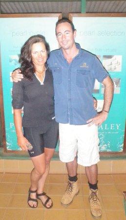
Sam Marshall, manager of the Kuri Bay Pearl Farm, sending me off at 5am
I woke from the mutual alarm making noise all over the pearl farm at 4am. The workers start their day quite early! But I was ready to go anyway.
I filled my water bags for the last 5 days to Cape Leveque, had a few nibblings in the canteen for breakfast and packed my boat in the darkness.
Sam Marshall waved me good bye, thanks for hosting me on the pearl farm! It was a good pit stop, but too short as usual on such occasions.
A small croc was floating close to me launching in the darkness, but I was not worried about this one at all. You’re getting used to their presence, and Sam said there are no BIG ones in the bay…trust him!
It was dark for another 45 min after launching, but to find my way out of the bay was no problem with my well-lit GPS.
The pearl farm workers were already passing me on their way to enter their work boats for the day. They were about 25 people, and another 10 or so staying ashore.
The water was quiet and I felt little tidal stream action only until I I was passing Hall Point where tide was with me then for the afternoon.
I was thinking of taking advantage of the afternoon tides and it may be a clever idea to cross over to the High Cliffy Islands on the eastern side of the big Montgomery Reef already that day, instead of staying close to the shore and spending the night at Freshwater Cove.
I should have checked landing possibilities on Google Earth, but the pearl farm computer didn’t have Google Earth…
I trusted my experience that reef islands usually always had a beautiful beach, but this time the name should have warned me!
The beaches were not accessible at all on any of those islands. There were just rocks and rocky reefs…at least what I saw in last light arriving.
There was a scrap of beach on the north-eastern side with sand, but it didn’t appear to stay dry to me, so I left it aside and kept on searching.
On deciding to do the crossing to the High Rocky Islands that afternoon I definitively took into account I may have to stay afloat when I won’t find a good landing, but I was not really expecting it!
But it was the case. I gave Greg a call to check on Google Earth for a possible landing site on the islands, but all he could see was what I saw already…no chance! If I would have asked him earlier to check Google Earth I would have known, but I would have needed to know myself changing my float plans so spontaneously…but oh well…
I kept on paddling slowly south against a bit of stream to the reef edge, until I could turn westwards. This was all in dark night, only lit by the stars. Thanks to my well-lit-GPS…The moon was non-existing that night, it came out only in the last hour with a very small bit.
I checked my drift once I was on the southern reef side, and it appeared it was marginal. I could afford frequent powernaps without being drifted much north onto the reef or backwards. Thank goodness. As I didn’t get much sleep last night, I was simply tired as hell. I napped mostly crunched forward, with the paddle held across on my cockpit coaming. It was quiet water that night, and I didn’t feel the need to go for a “proper” sleeping setup, as I was not sure about how the drift would continue.
I power napped, paddled a bit, power napped again…sometimes laid back on my back deck with the paddle in my hand as well. It was working all right, good enough to “survive” the night until dawn at 5.30am.
I rather napped more than making good progress. The stars were shining all night, and I could even make out the halo of the mining settlement if Koolan Island, right into the direction I was heading. It was a great steering help. When I woke again from a nap, still half asleep, I only needed to check where the halo was shining, and had to turn my boat into exactly that direction.
Text message from Freya via satellite phone:
Paddling through the dark of the night to Ceasar Island. Beaches on Momtgomery reef islands nothing worth to land on


8 comments on “Day 154, Saturday, 20.06.2009”
Janita, Hillary, etc.
Unless Freya (who certainly has better data than I) or one of her official representatives calls it differently, Broom sounds like a good place. Somebody much more attuned to Western Australia ought to name the exact time and date. Northern Virginia (my vantage point) is way too distant for that.
Chuck
Freya will be cutting right over the top of the sound. Going to Derby would be going into a dead end.
Yes, Broome!! But I am SURE Freya knows the exact halfway point.
“Unified formal recognition”..yes Chuck!
Synchronise glasses!
So are we all agreed? Broome is the collective “Congratulations to Freya” half-way point?
Does anyone know if Freya is planning on going to Derby, or cutting straight across to the Dampier Peninsula?
Based on the Trip Dates Table spreadsheet linked from her Trip Report (under the “Australia” tab), it looks to me like Freya passed the actual (versus symbolic) halfway point at some point between her camps at Wuwirriya Island (day 150 – 4261 total miles) and Ena Island (day 151 – 4295 total miles). This is based on a rough estimate of 8545 miles for her total distance to Queensclif (Paul Caffyn’s mileage to there was 9420 miles — his longer route around the Gulf of Carpenteria’s shoreline represents the difference). Of course, Freya’s and Paul’s actual distance will differ in other ways, but those differences should be relatively minor).
Accordingly, I have already hoisted my symbolic champagne glass (never touch the actual stuff — the bubbles get to me!) in honor of Freya’s achievement. She IS “Doing It”, and in remarkable time. For those of us who are following her progress, Broome would be the appropriate place for unified formal recognition.
sandy, how many days paddle is it do you figure 2 broome? that is the REAL 1/2 way point.
Broome is not far now! Keep up the amazing effort! I expect I’ll be seeing you sometime soon.
Comments are closed